Mountain Technical Archive

READ THE TERRAIN

Hiking becomes mountaineering the moment a slip or trip cannot be arrested before falling into vertical space. A technical trail demands more than aerobic fitness; it requires cold objective analysis of rock quality, weather windows, exposure tolerance, and self-arrest mechanics.


TECHNICAL ROUTE ANALYSIS

Trail / Mountain Location Technical Grade Exposure Level Typical Season
Crib Goch Arete Snowdonia, Wales Grade 1 Scramble Extreme (Sheer drop on both sides) May – October (Dry rock only)
Jabal Bil Ays Ridge Hajar Mountains, Oman Class 3 / Via Ferrata High (Loose scree over limestone cliffs) November – February (Avoid summer heat)
GR20 Cirque de la Solitude Corsica, France High Alpine Scramble Severe (Steep granite slabs, rockfall) Late June – September
The Drakensberg Grand Traverse South Africa / Lesotho Unmarked Wilderness Moderate to Extreme Escarpment Edge March – May / Sept – Nov
Huashan Plank Walk in the Sky Shaanxi, China Secured Plank Pathway Vertical 2,000m cliff face drop April – October
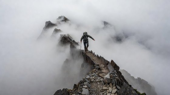
Hiker carefully balancing on razor-thin knife-edge rock arete shrouded in mountain clouds
Snowdonia National Park, UK Elevation: 923 m

Crib Goch: The Razor of Eryri

Crib Goch is a knife-edge arête formed by glaciation. The route allows no room for hesitation: to your left is a precipitous drop down towards Llanberis Pass; to your right is an equally unforgiving chute dropping into Cwm Uchaf. In gusty wind or rain, wet slate and greasy rhyolite become lethal. Hundreds of mountain rescue callouts occur here when novice hikers freeze with panic mid-traverse.

Rule of Thumb: Never attempt this ridge if wind speeds on the summit forecast exceed 30 knots or if frost covers the rock crest.
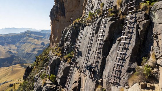
Steel chain ladders pinned directly to sheer basalt cliff in the Drakensberg
KwaZulu-Natal / Lesotho Elevation: 3,100 m

The Amphitheatre Chain Ladders

Gaining the high basalt escarpment of the Drakensberg requires scaling two sets of vertical chain-link ladders bolted into the bare cliff wall of Mont-aux-Sources. High winds whistle through the rungs as climbers climb with full expedition packs swaying against the rock. Once atop the plateau, hikers face frequent lightning strikes and completely unmapped territory.

Rule of Thumb: Inspect each welded link before committing pack weight; keep three continuous points of contact at all times.

How to Read Terrain Under Pressure

Terrain assessment is a skill cultivated over thousands of vertical meters. Novice adventurers look strictly at the ground beneath their boots; experienced navigators continually scan 50 meters ahead to spot micro-terrain bottlenecks, unstable talus cones, changes in rock texture that indicate moisture or black ice, and natural escape gullies before committing to an exposed ledge.

If your retreat route involves downclimbing damp rock or unprotected slabs, consider your retreat path closed the moment you step forward. Turning back early is not defeat; it is the fundamental reason veteran alpine explorers live to attempt subsequent routes.